As the leaves begin their slow transition from emerald to amber and the air carries that crisp hint of autumn, Connecticut residents are no strangers to the whims of New England weather. On this September 22, 2025, with the official start of fall just days away, whispers of an impending storm are circulating through coffee shops in Hartford, beachside chats in New Haven, and the endless scroll of social media feeds. The keyword on everyone’s mind? “Is there a storm coming to Connecticut?” It’s a question that evokes memories of nor’easters blanketing the coast in snow, summer thunderstorms rattling windows, and the occasional tropical intruder reminding us of our vulnerability to the Atlantic’s fury.
In this blog post, we’ll dive deep into the current atmospheric drama unfolding over the Constitution State. Drawing from the latest forecasts, historical precedents, and real-time chatter from locals, we’ll explore whether this is just another blustery bluff or the prelude to something more formidable. Whether you’re a lifelong Nutmegger battening down the hatches or a visitor planning a foliage tour, understanding the skies ahead is key to enjoying what makes Connecticut’s seasons so enchantingly unpredictable. Let’s break it down, forecast by forecast, with a dash of science, history, and practical wisdom to guide us through.
Current Weather Snapshot: A Calm Before the… What?
Today’s Conditions Across the State
As of September 22, 2025, Connecticut is basking in a deceptive calm. The National Weather Service’s latest update for Hartford—the state’s bustling capital—paints a picture of partly sunny skies with highs hovering in the low 70s°F (around 21°C). Winds are light out of the southwest at 5-10 mph, and humidity levels are comfortable at about 60%, a far cry from the muggy grip of midsummer. Coastal areas like Bridgeport and New Haven are seeing similar temps, though a touch cooler near the Long Island Sound, dipping to 68°F with a gentle sea breeze. Inland spots in Litchfield County report crisp mornings in the 50s, warming up nicely by afternoon—perfect for a hike through the Berkshire foothills.
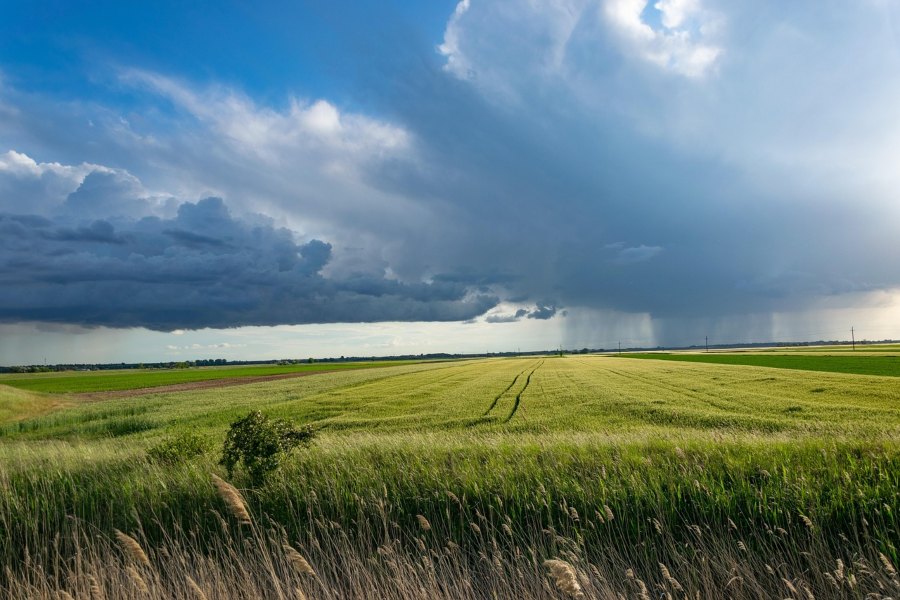
But don’t let the sunshine fool you. Satellite imagery from the Storm Prediction Center shows a lingering low-pressure system meandering off the Southeast coast, its tendrils occasionally teasing the Northeast with isolated clouds. No active warnings are in effect statewide, but the Day 2 Convective Outlook hints at a slight risk (Level 1 out of 5) for thunderstorms developing late Tuesday into Wednesday as a weak frontal boundary nudges northward. For now, it’s the kind of day that lulls you into complacency—barbecues firing up in backyards, kids kicking soccer balls in leafy suburbs, and fishermen casting lines off Rocky Neck State Park without a ripple of concern.
Regional Variations: From Shoreline to Highlands
Connecticut’s geography is a microcosm of New England’s diversity, and so is its weather. The shoreline, stretching from Stonington to Greenwich, often bears the brunt of coastal storms, with sea levels running 6-12 inches above normal due to recent lunar tides and subtle atmospheric pressure dips. Today, expect scattered clouds and a 20% chance of a stray shower in Fairfield County, courtesy of that offshore system. Head north to the Quiet Corner in Windham and Tolland Counties, and you’ll find drier, sunnier conditions—ideal for apple picking at Lyman Orchards, where the harvest is just hitting its stride.
Up in the northwest hills of Litchfield, cooler pockets could flirt with 65°F, with fog clinging to valleys like a reluctant lover. AccuWeather’s radar loop confirms no precipitation echoes over the state right now, but moisture from the remnants of a faded tropical depression is pooling just south, waiting for a spark. If you’re in Torrington or Danbury, that spark might come sooner—models suggest isolated pop-up showers by evening, brief but enough to water your mums without soaking the garden.
This snapshot isn’t screaming “storm alert,” but it’s the setup that meteorologists love to dissect: a high-pressure ridge dominating the Midwest, funneling mild air our way, while a pesky trough over the Great Lakes stirs the pot. For the average Connecticut commuter dodging I-95 traffic, it’s business as usual. Yet, as any seasoned resident knows, our weather has a habit of turning on a dime.
Short-Term Forecast: Thunder on the Horizon?
The Next 48 Hours: Building Tension
Peering ahead to September 23-24, the plot thickens. The Weather Channel’s 10-day outlook for Hartford forecasts a shift: Tuesday starts mild with increasing clouds and a high of 75°F, but by afternoon, 40% odds of scattered thunderstorms roll in. These aren’t your garden-variety summer pop-ups; the Storm Prediction Center flags a marginal risk for gusty winds up to 50 mph and hail the size of nickels in isolated cells, particularly along the I-91 corridor from New Haven to Springfield.
Why now? Blame a cold front slicing down from Canada, clashing with humid Gulf air that’s been loitering since last week’s warmth. NBC Connecticut’s radar blog notes similar setups earlier this month led to a severe thunderstorm watch on September 6, with large hail and tornado whispers that mercifully fizzled. This time, the front is weaker, but shear—wind changes with height—could whip up a supercell or two over the Naugatuck Valley. Expect downpours dumping 0.5-1 inch in an hour, enough to snarl rush hour on Route 8 but not flood basements… yet.
Coastal dwellers, take note: Wednesday brings a 30% shower chance under overcast skies, highs in the upper 60s. An offshore low, reminiscent of the disorganized system that brushed us on September 10, will sling bands of drizzle our way. Winds pick up to 15-20 mph from the east, churning waves to 4-6 feet— a surf advisory might drop for Hammonasset Beach, where riptides lurk like hidden adversaries.
Into the Weekend: Clearing or Complicating?
By Thursday, September 25, high pressure rebounds, ushering in a classic fall crispness: sunny skies, lows in the 40s, highs brushing 70°F. WTNH’s Storm Team 8 echoes this, predicting a dry stretch through Sunday—prime time for the Big E in West Springfield or a drive along the Merritt Parkway’s golden arches of foliage. But hold the cider toasts; longer models from the Almanac hint at below-normal precipitation for September overall, yet a wildcard storm eyeing the West Coast could pivot eastward by late month, bringing another rain round. AccuWeather’s severe weather page, though glitchy today, historically flags these as “watch zones” for flash flooding in urban areas like Waterbury.
In short, the short-term vibe is “storm lite”—thunder possible, but no apocalypse. Still, with climate patterns shifting, even mild events pack a punch.
Historical Echoes: When Storms Have Rocked Connecticut
The Infamous 1938 Hurricane: A Century’s Shadow
No discussion of Connecticut storms is complete without invoking the ghost of September 21, 1938. Yesterday marked the 87th anniversary of the Great New England Hurricane, a Category 3 monster that slammed Long Island before barreling into the Nutmeg State with 120 mph winds and a 25-foot storm surge. In Bridgeport, waters rose 18 feet, drowning streets and snapping 500,000 trees like matchsticks. The toll? Nearly 100 dead in Connecticut alone, thousands homeless, and economic scars that lingered for decades.
The NWS’s retrospective storymap details how the storm’s rapid intensification—fueled by warm Atlantic waters—caught forecasters flat-footed, with no satellites or radar in those days. Fast-forward to today: We’ve got hurricane hunters, ECMWF models, and apps pinging alerts. Yet, as Tropical Storm Larry’s remnants buried parts of the state in freak early snow last winter (as one X user recalled), history whispers that anomalies persist.
Modern Mayhem: Nor’easters and Thunder Bombs
Connecticut’s storm ledger is thick. The 2011 Halloween Nor’easter dumped 30 inches on Northern Fairfield County, crippling power for 800,000. Superstorm Sandy in 2012 redefined coastal fury, with 8-foot surges flooding Fairfield’s garages and $50 billion in regional damage. More recently, July 2023’s “thunder bomb” unleashed 100 mph straight-line winds, toppling 1,000-year oaks in Cheshire and leaving Eversource scrambling.
These events aren’t relics; they’re patterns. September, with its warming oceans, averages 3 rainy days but hosts 20% of the state’s tropical threats, per Weather25 data. EF-1 tornadoes, like those confirmed in neighboring Massachusetts on September 6, remind us that even “mild” storms spin up twisters. And let’s not forget the 2020 October rainstorm in Wolcott, where Mad River swelled into a chocolate torrent after 4 inches fell in hours—a scene photographer George Steffanos captured vividly.
What ties these? Climate change: Warmer air holds 7% more moisture per degree Fahrenheit, per IPCC reports, amplifying rainfall by 20-30% in Northeast storms. Connecticut’s 2025 has already seen a rain deficit despite weekend soakings, heightening drought risks in eastern counties. If our current system intensifies, it could echo these echoes—minus the surprise.
Science Behind the Storm: Why Connecticut Gets Hit Hard
Atmospheric Dynamics: Fronts, Pressure, and the Jet Stream
Storms aren’t random; they’re symphonies of physics. At its core, our potential squall stems from the polar jet stream—a river of 100 mph winds 30,000 feet up—dipping south and steering that Canadian front our way. As it collides with Atlantic moisture, instability brews: Warm, humid air rises, cools, condenses into thunderheads. CAPE (Convective Available Potential Energy) values around 1000 J/kg today signal “go time” for updrafts, per SPC graphics.
Connecticut’s topography amplifies this. The Berkshires and Taconic Range force air upward, wringing out orographic rain—think 2 inches in Litchfield versus 0.5 in coastal plains. Add the Long Island Sound Convergence Zone, where sea breezes collide, and you get enhanced thunderstorms over New Haven, as seen in last week’s watch.
Climate’s Long Game: Trends and Projections
Zoom out: NOAA data shows Northeast hurricanes intensifying 10% since 1980, with sea levels up 10 inches since 1900—bad news for Stamford’s waterfront. September 2025’s average temps (14-24°C) align with norms, but extremes are edging up: A 1-in-5 year storm now hits 1-in-3. Projections for 2050? 20% wetter falls, per Climate Central, straining the Farmington River and boosting mold in basements.
Yet, positives: AI-driven forecasts, like UConn’s models sharpening predictions, cut warning times from hours to minutes. Tools like WFSB’s Early Warning Weather app keep us ahead.
Voices from the Ground: What Connecticuters Are Saying
Social media is the pulse of public weather anxiety, and X (formerly Twitter) is buzzing. A search for “storm Connecticut” since September 15 yields a mix of nostalgia and nerves. Storm chaser Kevin Bergeron in Bristol spotted northern lights on September 18—a KP index 3 rarity—but fretted over no chases yet. Photographer Justin Zepperi’s aurora pillars from Staffordville on September 16 wowed 1,800 views, blending cosmic beauty with storm-watch vibes.
Reminiscences dominate: Users like @CandiceOwe19806 and @LostSiren13 recall Storm Larry’s freak snow burial, joking about shoveling in T-shirts. The NWS’s 1938 anniversary post garnered 4,000 views, sparking threads on preparedness. Lighter fare? Hockey’s Atlanta Madhatters “storming” Connecticut for a game, or Charli D’Amelio facts tying Norwalk to TikTok tempests.
One political twist: @Zygotehuman urges “storming” the CT GOP amid tax woes, a metaphorical tempest. Overall, sentiment? Cautious optimism—no panic, but eyes on the radar.
Preparation Pointers: Storm-Proofing Your Connecticut Life
Essentials for the Household
If thunder rumbles, act fast. Stock a 72-hour kit: Water (1 gal/person/day), non-perishables, flashlight, batteries, and a NOAA radio tuned to 162.400 MHz for NWS broadcasts. For power outages—Eversource’s bane—grab a generator or portable charger; Wednesday’s winds could down lines in 600 homes, as in recent events.
Secure outdoors: Trim limbs over roofs, clear gutters (fall leaves incoming), and anchor patio furniture. Coastal? Elevate valuables; FEMA’s flood maps flag 20% of Old Saybrook as high-risk.
Community and Tech Tips
Join alerts: DEEP’s CT Alert app or ReadyCT.gov for tailored warnings. Schools like those in Middletown drill for closures—check NBC CT’s list. Drive smart: Avoid low spots on Route 34 during heavy rain; hydroplaning claims lives yearly.
For families, games beat fear: Build a fort during outages, or track the storm via Fox61’s radar. Pets? Crate them early—thunder phobias spike vet calls.
Broader Impacts: Economy, Ecology, and Everyday Life
Economic Ripples
Storms sting wallets: Sandy’s $5 billion CT hit shuttered casinos, flooded farms. A mild thunder event? $10-50 million in outages, crop losses—think $2 million to apple yields if hail strikes Lyman Orchards. Tourism dips too; foliage drives $1 billion annually, but rain keeps leaf-peepers home.
Positively, recovery boosts: Tree services boom in Wolcott, insurers hire adjusters.
Ecological Angles
Storms reshape: 1938’s surge eroded beaches, but replanting efforts birthed resilient dunes at Hammonasset. Today, wetter falls aid reservoirs like Barkhamsted, easing droughts. Wildlife? Migratory birds detour, but amphibians thrive in puddles. Long-term? Rising seas threaten salt marshes in Branford—DEEP’s $100 million restoration fights back.
Daily Disruptions and Silver Linings
Commutes crawl on wet I-84; flights from BDL delay. But cozy nights in? Rain pattering on New Canaan’s roofs inspires books or board games. Storm chasers like Bergeron find thrill; aurora hunters like Zepperi, magic.
Wrapping Up: Eyes to the Sky, Feet on the Ground
So, is there a storm coming to Connecticut? As of September 22, 2025, the answer is a qualified yes—a scattered thunderstorm Thursday, perhaps showers over the weekend, but nothing biblical. No Category 3 redux, no Sandy-scale surge. Yet, in the spirit of our resilient state—from 1938’s rebuilds to today’s AI forecasts—vigilance is our superpower.
Connecticut’s charm lies in these transitions: Sunshine yielding to squalls, calm to chaos, summer’s end to fall’s embrace. Whether you’re storm-chasing in Bristol or picnicking in Preston, stay informed, stay prepared, and savor the show. The skies may rumble, but the Nutmeg State’s spirit? Unshakable.
What do you think—is this just bluster, or the setup for something bigger? Drop your forecasts in the comments. Until next squall, clear skies (or not) from the Constitution State.
Related Post